Today I’d like to take you out for a field trip. My intention is not just to take you to some of the most scenic natural and technological locations in the Anthropocene, but also to reflect a bit on the increasing entanglements of nature and technology. One of several project ideas I’ve been exploring the last year or so is a study of the ways in which “nature” and “the digital” have become intertwined since the 1960s, more or less. I say “nature” because there are, in fact, many natures. Some we see. Others we eat. Some we travel through. Some are hidden from us. Our idea of nature has expanded quite dramatically as a result of both new scientific instruments and new nature management regimes. The natural world becomes both bigger and smaller at the same time, extending out in space and down into our own bodies.
We know from science studies that we generally can’t know this “nature” directly. This idea of nature is becoming very hard to separate from the digital tools and media we use to observe, interpret, and manage it. Our ideas, our standards, for what is natural is distributed and maintained in digital tools and media like databases, computer models, geographical information systems, and so on. I can point to Paul Edwards’ prize-winning book on computer modeling and climate change, A Vast Machine: Computer Models, Climate Data, and the Politics of Global Warming as one recent example of studies really highlighting this perspective.
Such a perspective on nature pulls us in a few different directions. Up, towards abstraction and global management systems, like Edwards and his vast machines. But also down, out into the field, to the bodily experience of nature. I call these distant and close natures, directly borrowing from Stanford literature professor Franco Moretti’s ways of reading literature on different scales. And in what I have chosen to call annotated landscapes, the close and the distant overlap. If we think about how we often navigate landscapes now, accessing these invisible digital layers of information that annotate the landscapes as we move through it, using a handheld GPS-enabled device (finding out our direction, speed, altitude, routes, weather forecasts, notable attractions and their history, where’s the nearest Starbucks, etc.), we are simultaneously moving in both natures at once, both the immediate and physical on one hand, and the digital and distributed. It is in this loop of circulating natures that we experience and navigate the world around us.
What does this mean for the way we experience nature in the Anthropocene? First, it means that we only rarely access and experience nature directly, unfiltered and unprocessed by any form of technology. Second, there is no ”nature” without technology (and by that I mean our ideas about nature, the combination of the nature in our head and the nature ”out there”). In other words, the digital distribution of nature is just one more example of how hard it is to talk about a ”pure” nature in the Anthropocene. We could explore this entanglement of digital media, technologies, and the natural in many different ways, but since my blog posts here at Forskerbloggen have a tendency to get rather long, let us limit ourselves to one aspect of digital mapping that aims to really mediate the experience of the places they depict.
Touring the world on Google Maps
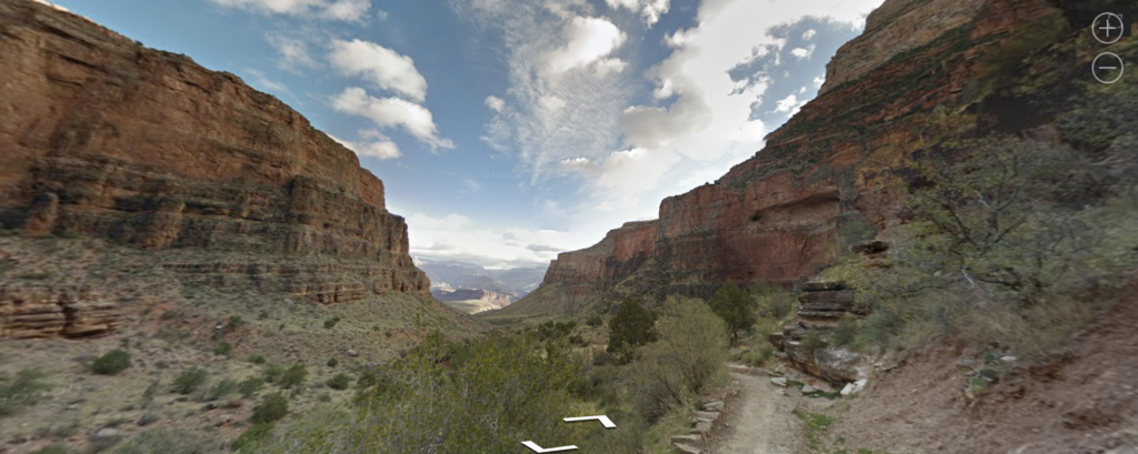
I think we all know know Google Maps, and most of us have probably also used Google Street View. You may perhaps even have seen the Google Street View car, a logo-filled Toyota Prius with a large black ball on a pole on the roof (I have seen it 3-4 times – and if you skip to the bottom of the post, you can see what happened when the car saw me as well). We have come to take the road-based street view scenes more or less for granted, a logical extension of GPS-based driving instructions. Still, many were upset when Google took Street View off the road and into what we consider natural areas. In 2012, Google added a walking tour of the Grand Canyon National Park, one of the most impressive nature tourism destinations in the world. The critics argued that such a digital representation of this area could not possibly give the right impression of one of the most sublime natural scenes in the world, and that Google thus shouldn’t even try to do it.
If we take a longer view of this development, what Google is doing is no different from what the pioneering tourist explorers of the 1800s did. They more or less walked by foot to every corner of Scandinavia (and elsewhere), identifying scenic locations and bringing them back to other people through writing, painting, and eventually taking pictures of these places. Many went further in even developing travel infrastructures, with roads, maps, and lodging near the tourist destinations that they identified, as a way of making it all more accessible. These were the kind of people who started the various national trekking associations worldwide, including Svenska Turistföreningen in 1885, to develop national nature-based tourism. In doing so, they cultivated a particular visual genre of appreciating nature (there is a much larger backstory about changing the idea of nature from a desolate wasteland to a sublime and valuable experience, as well as one of national romanticism). In this new genre, accessibility was just as important as authenticity.
So let us start our virtual field trip, going across the world. Below you can find a collection of Google Street View scenes – they can all be navigated using your mouse: you can pan and zoom around, and even walk around. As this collection can be quite taxing for your computer, I have only included a few examples below, but if you visit the Google Street View Gallery, you can find an amazing collection of scenes, including World Heritage Sites, mountains, railroads, underwater locations, and so on. I can also recommend the Google Sightseeing blog (with the charming slogan ”Why bother seeing the world for real?”).
EMBEDDED STREET VIEW SECTIONS HAVE BEEN REMOVED FOR TECHNICAL REASONS
Let us be clear – such virtual field trips are not meant to be a replacement for the bodily experience of being in a particular place. I wouldn’t call it an inferior experience either. Instead, it is a different way of experiencing particular places, most of which we will never get to see in person (and if most of us did get a chance to do it, the places would most likely be changed beyond recognition – the so-called tourist’s dilemma). The question is whether these Street View experiences make us appreciate places we’ve never experienced in person, if they make us more or less aware of diversity, of development, of environmental change, and so on. Is it possible to use virtual field trips such as these in teaching, for instance? If we manage to move beyond the simple ”it’s not real nature”-level of criticism, what can Google Street View tell us about the world?
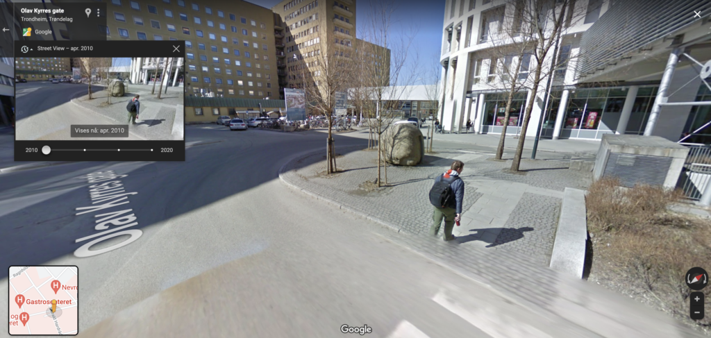
Finally, as a bonus for those of you who managed to read the entire post – a portrait of the author on Google Street View, outside St. Olav’s Hospital in Trondheim. I apologize for my somewhat rough look – my youngest daughter had been born just a few days ago, and I think I had spent the night on a couch in the hospital. The Google car took me completely by surprise.